The Berlin Wall
© Berlin Wall Foundation, Photo: Michael-Reiner Ernst
Index
The 155-kilometer-long Berlin Wall, which cut through the middle of the city center, surrounded West Berlin from August 13, 1961 to November 9, 1989. The Wall was designed to prevent people from escaping to the West from East Berlin. In 1961, the Socialist Unity Party of Germany (SED) began adding additional obstacles to the border, expanding the Wall into a complex multi-layered system of barriers. In the West, the border strip was referred to as the “death strip” because so many people were killed there while trying to escape. In 1989, the Wall that the SED had used for so long to maintain its power in the GDR, fell. With the fall of the Wall, the dictatorship came to its definitive end.
After World War II ended in 1945, the SED, the state party of the GDR, established a dictatorship in East Germany with the support of the Soviet occupying power. A large part of the East German population did not agree with the new political and economic system. By the late 1940s, a mass migration to the West was underway. People had different reasons – political, economic and personal – for wanting to leave. By August 1961, the GDR had lost a sixth of its population – at least four million people. The SED had already closed off East Germany’s border with West Germany in 1952, making it increasingly dangerous to cross there. But the sector borders in Berlin remained open, leading many to try to reach West Germany through this last opening.
On August 13, 1961, the SED began to seal off the borders around West Berlin, first with barbed wire and a few days later with walls. It hoped this measure would put an end to the mass exodus to Berlin. It also wanted to stabilize its power and document its sovereignty to the outside world. But not even barbed wire and the Wall could stop people from fleeing. The efforts to perfect the border fortifications in Berlin continued until 1989.
Soldiers and a construction crew at the Bernauer Strasse border fortifications © Berlin Wall Foundation, photo: private
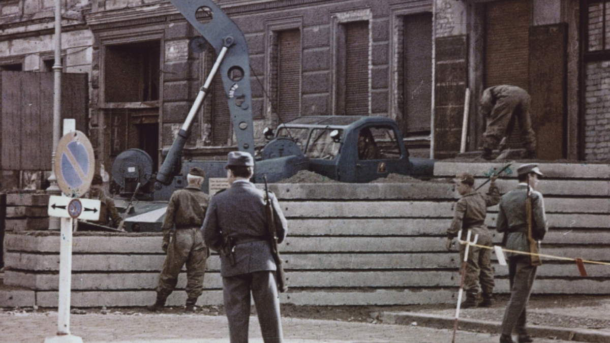
Even after the Wall was built, the SED leadership was not able to completely stop the westward migration. In fact, now that the Wall separated friends and family in Berlin, the pressure on East Berliners and people living on the outskirts of Berlin to flee was even greater. This, in turn, led the SED to further expand the border fortifications. What began as a single wall evolved into a complex, multi-layered border installation designed to prevent escapes.
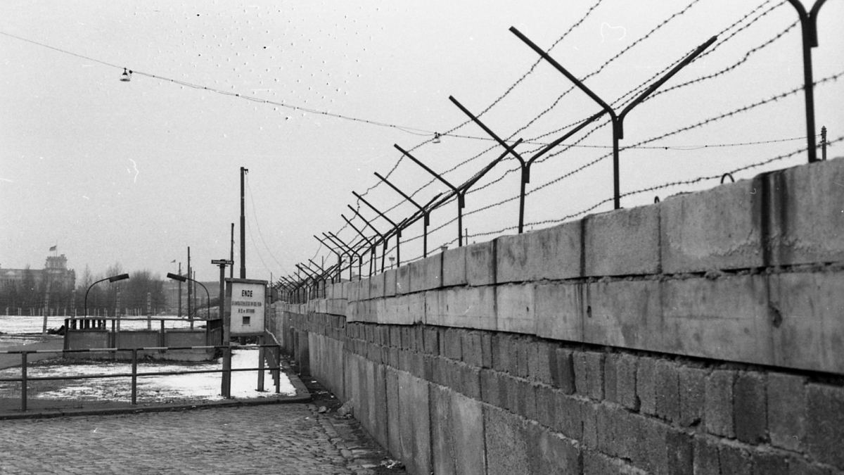
In the beginning, when a successful escape occurred, border soldiers and pioneer units added temporary, individual barriers to a specific site behind the border wall. After the border area was established behind the Wall on the East Berlin side in 1963, a fence was added to block off large parts of this area. In the mid-1960s, the SED tore down several buildings to make room for a uniform border strip that provided border soldiers with an “unobstructed view and clear field of fire.” Over the following years this border strip was continually expanded and improved. In the 1970s, a second “inner wall” was added, blocking off the border strip to East Berlin and the GDR.
The border wall at Potsdamer Platz © Berlin Wall Foundation, photo: Michael-Reiner Ernst
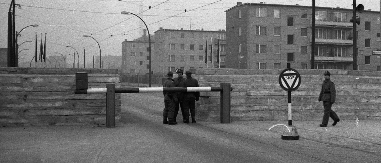
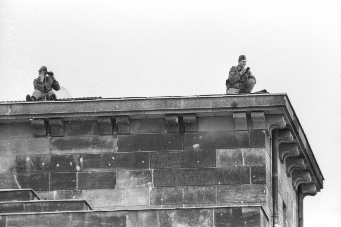
Dog runs were also installed in some areas so that watchdogs could block the path and alert border soldiers of an approaching intruder. At night the border strip was lit brightly by a line of lamps, making it easier for border soldiers to see someone fleeing in the dark. Shadows were more visible against both walls, which were painted white on the sides facing inward. The watchtowers stood approximately 250 meters apart, providing border guards with a good view of their section of the border. Guards on the towers observed the border strip and the rear border territory. They were on the constant lookout for anyone trying to flee, ready to stop their escape at an early stage. The border soldiers were also expected to keep an eye on the West Berlin territory on the other side of the Wall.
In the late 1970s, the SED leadership rebuilt the border wall. Hoping for international recognition, it no longer wanted the East German capital’s public image to be dictated by the menacing border fortifications with their metal gratings, bunkers and vehicle obstacles. These types of barriers were removed from the border strip by 1983. They were less essential to stopping escapes now that the new Wall had a greater “blocking capability” and surveillance had improved in the rear border territory and throughout the entire GDR. By the late 1980s, shortly before the Wall fell in 1989, almost all of the menacing obstacles between East and West Berlin had been removed from the border.
-

Bornholmer Strasse border crossing on Bösebrücke, 3 May 1979 © Berlin Wall Foundation, photo: Edmund Kasperski
-

Opened Chausseestrasse border crossing post, November 1989 © Berlin Wall Foundation, photo: private
-

High security border crossing post Heinrich-Heine-Strasse with command tower, autumn 1988 © Berlin Wall Foundation, photo: Jan Herrmann-Dangl
-

Cars waiting at the Friedrichstrasse border crossing, 17 November 1989 © Berlin Wall Foundation, photo: Lothar Heinze
-

Oberbaumbrücke border crossing and the Spree, 2 January 1980 © Berlin Wall Foundation, photo: Edmund Kasperski
-

Cars queuing at the Invalidenstrasse border crossing © Berlin Wall Foundation, photo: Hans-Joachim Grimm
-

Sonnenallee border crossing sign: ‘You are leaving the american sector’, probably before 1972 © Berlin Wall Foundation, photo: Hans-Joachim Grimm
-

Checkpoint at Friedrichstrasse station, May 1990 © ELAB, Archive of the Church of Reconciliation, photo: Christian Klopf
After the Wall was built, the SED government established seven road crossings and one railway crossing between East and West Berlin where West Berliners, citizens of the Federal Republic of Germany, and foreign nationals could cross the border. For most GDR citizens, however, crossing the border was strictly forbidden. Travel between West Germany and West Berlin was handled via transit routes with additional crossing points.
For the SED government, the border crossings were both an expression of its state sovereignty and unwelcome ‘holes’ in the Wall that facilitated escape routes and allowed people to enter the GDR from West Germany. The SED, therefore, tried to demonstrate both openness and total surveillance at the same time.
After the Wall fell, the border crossings in Berlin disappeared almost entirely from the cityscape. Commemorative markers can now be found at some of the sites. There are plans in place to create a permanent memorial at the Friedrichstrasse/Zimmerstrasse border crossing, which became famous as Checkpoint Charlie.
The Wall and border fortifications alone were not enough to stop escapes. The Wall also had to be guarded by armed soldiers who were ordered to use their weapons if they were otherwise unable to stop the escape. In the West, this was referred to as the “order to shoot.”
The use of firearms on the GDR’s western borders was regulated by internal directives and commands. An official law, the “GDR border law,” was not passed until 1982. But independent of the changing situation, beginning in 1952, a verbally dictated command was in place that required border policemen and border soldiers to shoot at a fleeing person if they were otherwise unable to prevent the escape.
Many people lost their lives at the GDR border due to firearms. Of the 140 total deaths that occurred at the Berlin Wall between 1961 and 1989, 91 of the victims – mostly people trying to flee – had been shot by GDR border soldiers. The order to shoot was not lifted until April 1989. It became totally obsolete when the border opened in November.
When subdividing Berlin, the Allied powers used former administrative boundaries as a point of reference. This resulted in ten Berlin exclaves situated in the Brandenburg hinterland, which remained part of West Berlin but were surrounded by GDR territory. These areas led to frequent disputes. In particular, the exclave of Steinstücken became a source of friction because its residents had to pass through GDR territory to reach their homes. The problems intensified after the Berlin Wall was built.
The exclaves eventually became part of the Quadripartite Agreement of September 3, 1971, which stipulated that territory could be exchanged.


Authorised by the Western Allies, the West Berlin Senate negotiated with the GDR and reached three agreements by 1988:
- First agreement (1972): The GDR was awarded an area of 15.6 hectares. West Berlin received 17.1 hectares in return, including a direct road connection to Steinstücken. West Berlin also paid 4 million Deutsche Mark as compensation.
- Second agreement (1972): West Berlin received 8.5 hectares at the former Potsdamer Bahnhof, now Potsdamer Platz, for 31 million DM.
- Third agreement (1988): West Berlin received 14 areas totalling 96.7 hectares along the inner and outer city boundaries, including the Lenné Triangle, for which it paid the GDR 76 million DM. In return, the GDR took over the last three exclaves of West Berlin, which amounted to roughly 80 hectares.
The territory exchanges, which remained in place until the end of the GDR, were confirmed in the Unification Treaty as city district boundaries and the border between Berlin and Brandenburg.
The Exclaves
Steinstücken
Steinstücken, a settlement of roughly 12 hectares near the city limits of Potsdam, belonged to the West Berlin district of Zehlendorf. It was initially administered separately, but became part of Berlin in 1920. After the Second World War, Steinstücken belonged to the American sector, but was surrounded by the GDR. From 1945 to 1971, it was the only inhabited exclave of West Berlin in the GDR.
The GDR briefly occupied the settlement in 1951, but withdrew again after the Americans intervened. When the GDR erected barriers along the inner-German border and the border between the GDR and West Berlin in 1952, Steinstücken and its 200 inhabitants were also sealed off. Access to the area was only possible via a route controlled by the GDR. After the Wall was built in 1961, the U.S. stationed three soldiers at the site and used helicopters to ensure access - both for supplies and to demonstrate the airlift’s continued existence. Finally, in 1971/2, following an exchange of territory between West Berlin and the GDR, a direct connection was established between Steinstücken and West Berlin. A road provided direct access and a connection to local public transport. The energy and water supply was gradually switched from the GDR to West Berlin.
Lenné-Dreieck
The so-called Lenné-Dreieck (Triangle), which covers roughly 4 hectares and lies between the Grosser Tiergarten and Potsdamer Platz, was the subject of the third territorial exchange agreed between the GDR and the Senate of West Berlin in 1988. The triangular area bordered by Lennéstrasse, Bellevuestrasse, and Ebertstrasse had belonged to the Mitte district since 1920 and thus to the Soviet sector after 1945. When the Wall was built in 1961, the GDR installed barriers in a straight line along Ebertstrasse, cutting off the tip of the area belonging to East Berlin. The grounds remained a provisionally fenced-off wasteland until 1988. The Lenné-Dreieck was assigned to the West Berlin district of Tiergarten under the third territorial exchange agreement.
Occupation in May 1988
In the run-up to the exchange agreement, West Berliners occupied the Lenné-Dreieck on May 25, 1988, primarily in protest of the motorway construction planned here by the Senate. When the site was evacuated on July 1, 1988, more than 180 squatters ‘fled’ over the Wall to East Berlin. They were allowed to return to West Berlin via the usual border crossings a short time later.

Occupied Lenné-Dreieck near Potsdamer Platz, June 12, 1988 © Berlin Wall Foundation, Photo: Jan Herrmann-Dangl
At the Conference on Security and Cooperation in Europe (CSCE conference) in Helsinki in 1975, the SED agreed in principle, albeit without wanting to admit it, to the rights of people to move freely and enjoy freedom of travel. Afterwards, more and more GDR citizens submitted applications to immigrate permanently to West Germany. An opposition movement also developed in the 1980s that expressed pointed criticism of the political and social conditions in the GDR. The general public, angered by environmental pollution and economic stagnation, turned away from the SED state. Similar developments were taking place in other Eastern Bloc countries, such as Poland, where the independent trade union Solidarność achieved national recognition in November 1980.
After Mikhail Gorbachev became General Secretary of the Communist Party in the Soviet Union in 1985, the political situation in the Eastern Bloc slowly began to change. Gorbachev introduced internal political reforms to solve serious economic and social problems. In 1988 he abandoned the Brezhnev Doctrine, a central political principle of Soviet foreign policy that demanded limited sovereignty of the Warsaw Pact nations. This change allowed the Eastern Bloc states to set their own national policies. Hungary’s shift towards the West led it to demonstratively dismantle its border fence on May 2, 1989. The first hole was made in the “Iron Curtain.”
The SED was not interested in adopting the Soviet Union’s reform course in the GDR. But the country’s growing protest movement and the migration wave to the West in the late 1980s brought the dictatorship to an end in 1989. The SED had been compelled to make concessions, such as opening up travel to its citizens. When a new travel law was mistakenly announced on November 9, 1989, crowds rushed to the border, which was opened under the onslaught of so many people. The fall of the Wall led to the ultimate collapse of the GDR.
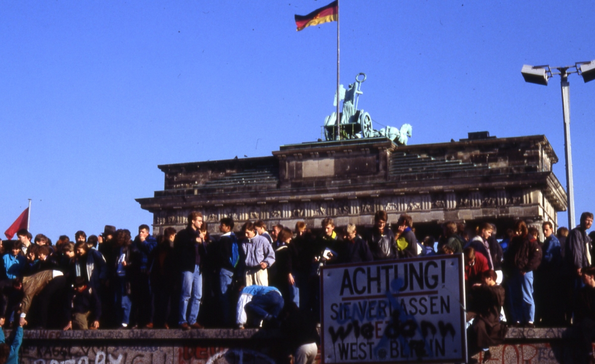
Celebrating people on the wall at the Brandenburg Gate the day after the fall of the wall. 10 November 1989 © Berlin Wall Foundation, Photo: Michael-Reiner Ernst
The demolition of the Wall began soon after the border opened. So-called “wall peckers” broke off pieces of concrete as souvenirs. New border crossings were created, leaving behind large gaps in the Wall. Border soldiers began dismantling the signal fence and other border obstacles. Both the GDR government and the border troops began thinking about ways of marketing the Wall. Pieces of the Wall were sold all over the world.
In June 1990 the systematic dismantling of the border grounds began at Ackerstrasse, between the districts of Wedding (West Berlin) and Mitte (former East Berlin), and was basically finished by the year’s end. The East Berlin magistrate placed the first sections of the Wall, including the section on Bernauer Strasse, under protection as a historical monument in 1990.
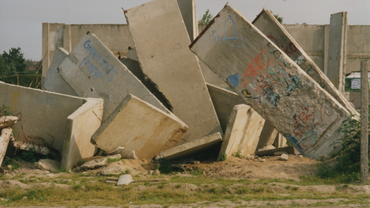
Demolished wall remains, Berlin Summer 1990 © Berlin Wall Foundation, Photo: Ute Hoog
Numerous remnants of the Berlin Wall are still visible in Berlin's urban space today. The online portal ‘Mauerspuren’ allows visitors to retrace the remaining remains and remnants of the Wall. An interactive map, on which the various remains of the Wall are marked, provides helpful orientation.